|
|
|||||||||||||||||
| Point ID: 7839 | Downloads | Plots | Site Data | Code: 3242 |
|
|
|||||||||||||||||
| Download | |
|---|---|
| Site Descriptor Information | Site Time Series Data |
| Link to all available data | |
| View: | Time Series | All |
| Units: | m3/s |
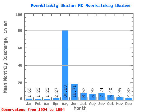
| Statistic | Jan | Feb | Mar | Apr | May | Jun | Jul | Aug | Sep | Oct | Nov | Dec | Annual |
|---|---|---|---|---|---|---|---|---|---|---|---|---|---|
| Mean | 1.69 | 1.25 | 1.23 | 2.27 | 80.67 | 18.71 | 8.52 | 6.92 | 7.74 | 5.39 | 2.99 | 2.32 | 140.19 |
| Standard Deviation | 1.07 | 0.69 | 0.70 | 3.84 | 28.81 | 13.53 | 6.92 | 4.98 | 7.90 | 4.15 | 1.90 | 1.64 | 43.29 |
| Min | 0.23 | 0.01 | 0.00 | 0.17 | 17.03 | 1.72 | 0.00 | 0.00 | 0.00 | 0.00 | 0.00 | 0.00 | 43.02 |
| Max | 4.38 | 2.53 | 2.95 | 22.77 | 140.40 | 50.33 | 30.46 | 18.94 | 42.78 | 20.06 | 7.93 | 7.02 | 280.19 |
| Coefficient of Variation | 0.63 | 0.56 | 0.57 | 1.69 | 0.36 | 0.72 | 0.81 | 0.72 | 1.02 | 0.77 | 0.64 | 0.71 | 0.31 |
 Return to R-Arctic Net Home Page