|
|
|||||||||||||||||
| Point ID: 7837 | Downloads | Plots | Site Data | Code: 3232 |
|
|
|||||||||||||||||
| Download | |
|---|---|
| Site Descriptor Information | Site Time Series Data |
| Link to all available data | |
| View: | Time Series | All |
| Units: | m3/s |
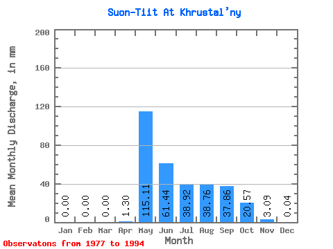
| Statistic | Jan | Feb | Mar | Apr | May | Jun | Jul | Aug | Sep | Oct | Nov | Dec | Annual |
|---|---|---|---|---|---|---|---|---|---|---|---|---|---|
| Mean | 0.00 | 0.00 | 0.00 | 1.30 | 115.10 | 61.44 | 38.91 | 38.76 | 37.86 | 20.56 | 3.09 | 0.04 | 365.31 |
| Standard Deviation | 0.00 | 0.00 | 0.00 | 1.67 | 49.02 | 30.04 | 23.19 | 27.92 | 25.41 | 11.64 | 3.66 | 0.13 | 123.30 |
| Min | 0.00 | 0.00 | 0.00 | 0.00 | 38.70 | 16.65 | 6.26 | 3.93 | 6.42 | 3.32 | 0.01 | 0.00 | 124.58 |
| Max | 0.00 | 0.00 | 0.00 | 6.30 | 195.32 | 106.30 | 83.78 | 98.52 | 90.36 | 43.61 | 10.70 | 0.42 | 563.95 |
| Coefficient of Variation | 1.28 | 0.43 | 0.49 | 0.60 | 0.72 | 0.67 | 0.57 | 1.19 | 3.16 | 0.34 |
 Return to R-Arctic Net Home Page