|
|
|||||||||||||||||
| Point ID: 7834 | Downloads | Plots | Site Data | Code: 3209 |
|
|
|||||||||||||||||
| Download | |
|---|---|
| Site Descriptor Information | Site Time Series Data |
| Link to all available data | |
| View: | Time Series | All |
| Units: | m3/s |
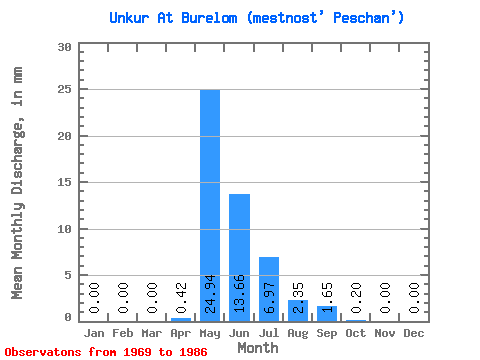
| Statistic | Jan | Feb | Mar | Apr | May | Jun | Jul | Aug | Sep | Oct | Nov | Dec | Annual |
|---|---|---|---|---|---|---|---|---|---|---|---|---|---|
| Mean | 0.00 | 0.00 | 0.00 | 0.41 | 24.92 | 13.67 | 6.97 | 2.34 | 1.64 | 0.21 | 0.00 | 0.00 | 52.49 |
| Standard Deviation | 0.00 | 0.00 | 0.00 | 1.18 | 19.69 | 21.62 | 18.83 | 5.70 | 2.43 | 0.36 | 0.00 | 0.00 | 44.72 |
| Min | 0.00 | 0.00 | 0.00 | 0.00 | 1.07 | 0.16 | 0.00 | 0.00 | 0.00 | 0.00 | 0.00 | 0.00 | 9.28 |
| Max | 0.00 | 0.00 | 0.00 | 4.87 | 67.03 | 81.43 | 81.78 | 24.13 | 8.11 | 1.31 | 0.00 | 0.00 | 193.81 |
| Coefficient of Variation | 2.87 | 0.79 | 1.58 | 2.70 | 2.44 | 1.48 | 1.69 | 0.85 |
 Return to R-Arctic Net Home Page