|
|
|||||||||||||||||
| Point ID: 7813 | Downloads | Plots | Site Data | Code: 3141 |
|
|
|||||||||||||||||
| Download | |
|---|---|
| Site Descriptor Information | Site Time Series Data |
| Link to all available data | |
| View: | Time Series | All |
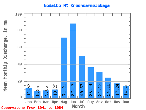
| Units: | m3/s |
| Statistic | Jan | Feb | Mar | Apr | May | Jun | Jul | Aug | Sep | Oct | Nov | Dec | Annual |
|---|---|---|---|---|---|---|---|---|---|---|---|---|---|
| Mean | 11.62 | 8.63 | 9.06 | 10.29 | 71.20 | 87.47 | 49.56 | 36.44 | 31.12 | 24.16 | 17.24 | 14.40 | 370.96 |
| Standard Deviation | 2.15 | 1.80 | 1.48 | 3.31 | 17.57 | 36.04 | 15.30 | 9.94 | 8.31 | 5.97 | 3.88 | 3.17 | 57.56 |
| Min | 7.84 | 4.92 | 5.60 | 7.54 | 39.78 | 30.87 | 21.91 | 20.69 | 20.41 | 14.41 | 11.40 | 10.32 | 248.27 |
| Max | 16.60 | 11.62 | 11.44 | 23.66 | 109.07 | 158.82 | 79.37 | 62.32 | 48.54 | 34.38 | 23.66 | 20.50 | 471.73 |
| Coefficient of Variation | 0.18 | 0.21 | 0.16 | 0.32 | 0.25 | 0.41 | 0.31 | 0.27 | 0.27 | 0.25 | 0.23 | 0.22 | 0.15 |
 Return to R-Arctic Net Home Page