|
|
|||||||||||||||||
| Point ID: 7805 | Downloads | Plots | Site Data | Code: 3115 |
|
|
|||||||||||||||||
| Download | |
|---|---|
| Site Descriptor Information | Site Time Series Data |
| Link to all available data | |
| View: | Time Series | All |
| Units: | m3/s |
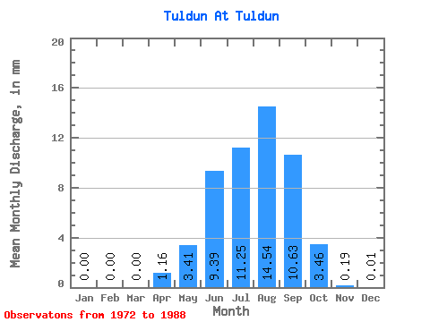
| Statistic | Jan | Feb | Mar | Apr | May | Jun | Jul | Aug | Sep | Oct | Nov | Dec | Annual |
|---|---|---|---|---|---|---|---|---|---|---|---|---|---|
| Mean | 0.00 | 0.00 | 0.00 | 1.16 | 3.41 | 9.39 | 11.24 | 14.54 | 10.63 | 3.46 | 0.19 | 0.01 | 57.71 |
| Standard Deviation | 0.00 | 0.00 | 0.00 | 1.81 | 7.41 | 14.81 | 12.85 | 13.76 | 10.97 | 3.13 | 0.23 | 0.02 | 52.38 |
| Min | 0.00 | 0.00 | 0.00 | 0.00 | 0.25 | 0.09 | 0.17 | 0.70 | 0.09 | 0.06 | 0.00 | 0.00 | 4.28 |
| Max | 0.00 | 0.00 | 0.00 | 6.00 | 25.50 | 46.16 | 41.09 | 35.88 | 30.78 | 7.67 | 0.71 | 0.05 | 136.22 |
| Coefficient of Variation | 1.56 | 2.17 | 1.58 | 1.14 | 0.95 | 1.03 | 0.90 | 1.21 | 2.60 | 0.91 |
 Return to R-Arctic Net Home Page