|
|
|||||||||||||||||
| Point ID: 7804 | Downloads | Plots | Site Data | Code: 3112 |
|
|
|||||||||||||||||
| Download | |
|---|---|
| Site Descriptor Information | Site Time Series Data |
| Link to all available data | |
| View: | Time Series | All |
| Units: | m3/s |
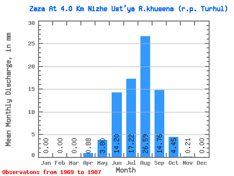
| Statistic | Jan | Feb | Mar | Apr | May | Jun | Jul | Aug | Sep | Oct | Nov | Dec | Annual |
|---|---|---|---|---|---|---|---|---|---|---|---|---|---|
| Mean | 0.00 | 0.00 | 0.00 | 0.88 | 3.80 | 14.20 | 17.22 | 26.59 | 14.77 | 4.45 | 0.21 | 0.00 | 84.36 |
| Standard Deviation | 0.00 | 0.00 | 0.00 | 1.60 | 5.69 | 24.90 | 17.20 | 25.18 | 12.26 | 3.19 | 0.21 | 0.00 | 66.77 |
| Min | 0.00 | 0.00 | 0.00 | 0.00 | 0.31 | 0.30 | 1.77 | 1.88 | 0.32 | 0.27 | 0.00 | 0.00 | 13.56 |
| Max | 0.00 | 0.00 | 0.00 | 6.80 | 25.34 | 110.46 | 69.22 | 85.08 | 37.88 | 10.69 | 0.86 | 0.00 | 220.58 |
| Coefficient of Variation | 1.83 | 1.50 | 1.75 | 1.00 | 0.95 | 0.83 | 0.72 | 1.03 | 4.12 | 0.79 |
 Return to R-Arctic Net Home Page