|
|
|||||||||||||||||
| Point ID: 7791 | Downloads | Plots | Site Data | Code: 3062 |
|
|
|||||||||||||||||
| Download | |
|---|---|
| Site Descriptor Information | Site Time Series Data |
| Link to all available data | |
| View: | Time Series | All |
| Units: | m3/s |
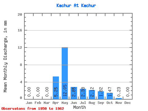
| Statistic | Jan | Feb | Mar | Apr | May | Jun | Jul | Aug | Sep | Oct | Nov | Dec | Annual |
|---|---|---|---|---|---|---|---|---|---|---|---|---|---|
| Mean | 0.00 | 0.00 | 0.00 | 5.25 | 12.06 | 2.85 | 2.37 | 2.12 | 1.82 | 1.47 | 0.23 | 0.00 | 28.73 |
| Standard Deviation | 0.00 | 0.00 | 0.00 | 5.23 | 12.56 | 3.96 | 3.23 | 2.83 | 2.33 | 1.81 | 0.42 | 0.01 | 21.14 |
| Min | 0.00 | 0.00 | 0.00 | 0.29 | 1.16 | 0.06 | 0.00 | 0.00 | 0.00 | 0.00 | 0.00 | 0.00 | 3.16 |
| Max | 0.00 | 0.00 | 0.00 | 19.29 | 34.75 | 14.19 | 11.00 | 7.97 | 6.17 | 4.46 | 1.39 | 0.05 | 73.83 |
| Coefficient of Variation | 1.00 | 1.04 | 1.39 | 1.36 | 1.34 | 1.28 | 1.23 | 1.86 | 3.61 | 0.74 |
 Return to R-Arctic Net Home Page