|
|
|||||||||||||||||
| Point ID: 7781 | Downloads | Plots | Site Data | Code: 70589 |
|
|
|||||||||||||||||
| Download | |
|---|---|
| Site Descriptor Information | Site Time Series Data |
| Link to all available data | |
| View: | Time Series | All |
| Units: | m3/s |
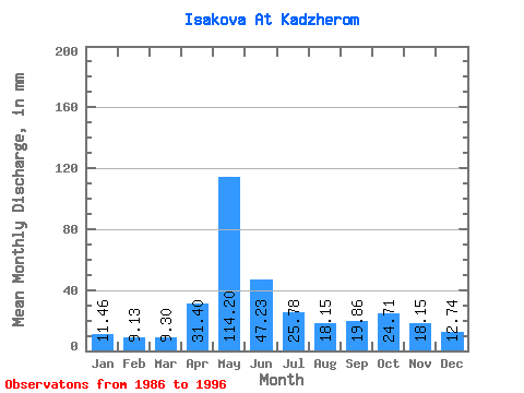
| Statistic | Jan | Feb | Mar | Apr | May | Jun | Jul | Aug | Sep | Oct | Nov | Dec | Annual |
|---|---|---|---|---|---|---|---|---|---|---|---|---|---|
| Mean | 11.45 | 9.21 | 9.30 | 31.40 | 114.19 | 47.23 | 25.78 | 18.14 | 19.86 | 24.70 | 18.15 | 12.74 | 332.74 |
| Standard Deviation | 2.57 | 2.51 | 2.48 | 43.48 | 33.87 | 23.01 | 11.73 | 4.47 | 6.04 | 7.37 | 6.61 | 3.07 | 44.49 |
| Min | 6.18 | 5.62 | 5.23 | 5.35 | 50.87 | 22.39 | 15.75 | 12.47 | 13.54 | 15.05 | 10.43 | 9.46 | 255.11 |
| Max | 14.50 | 12.78 | 12.42 | 145.55 | 164.80 | 93.10 | 55.15 | 28.52 | 31.14 | 37.08 | 29.91 | 20.76 | 396.55 |
| Coefficient of Variation | 0.22 | 0.27 | 0.27 | 1.39 | 0.30 | 0.49 | 0.46 | 0.25 | 0.30 | 0.30 | 0.36 | 0.24 | 0.13 |
 Return to R-Arctic Net Home Page