|
|
|||||||||||||||||
| Point ID: 7725 | Downloads | Plots | Site Data | Code: NO003 |
|
|
|||||||||||||||||
| Download | |
|---|---|
| Site Descriptor Information | Site Time Series Data |
| Link to all available data | |
| View: | Time Series | All |
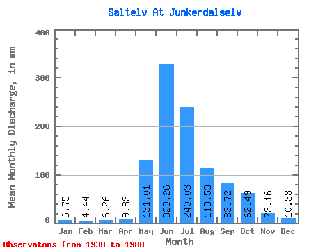
| Units: | m3/s |
| Statistic | Jan | Feb | Mar | Apr | May | Jun | Jul | Aug | Sep | Oct | Nov | Dec | Annual |
|---|---|---|---|---|---|---|---|---|---|---|---|---|---|
| Mean | 6.75 | 4.48 | 6.26 | 9.82 | 130.99 | 329.26 | 239.99 | 113.52 | 83.72 | 62.47 | 22.16 | 10.32 | 1016.40 |
| Standard Deviation | 5.51 | 2.48 | 9.65 | 12.20 | 77.80 | 93.47 | 76.16 | 34.96 | 31.75 | 31.47 | 15.23 | 8.48 | 167.38 |
| Min | 1.32 | 1.11 | 1.17 | 1.61 | 17.40 | 169.62 | 68.20 | 45.25 | 24.18 | 13.89 | 3.18 | 1.78 | 629.24 |
| Max | 28.39 | 13.95 | 63.16 | 76.51 | 334.73 | 569.25 | 423.32 | 198.71 | 177.09 | 175.06 | 61.59 | 41.71 | 1519.52 |
| Coefficient of Variation | 0.82 | 0.56 | 1.54 | 1.24 | 0.59 | 0.28 | 0.32 | 0.31 | 0.38 | 0.50 | 0.69 | 0.82 | 0.17 |
 Return to R-Arctic Net Home Page