|
|
|||||||||||||||||
| Point ID: 772 | Downloads | Plots | Site Data | Code: 07GH906 |
|
|
|||||||||||||||||
| Download | |
|---|---|
| Site Descriptor Information | Site Time Series Data |
| Link to all available data | |
| View: | Time Series | All |
| Units: | m3/s |
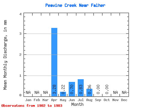
| Statistic | Jan | Feb | Mar | Apr | May | Jun | Jul | Aug | Sep | Oct | Nov | Dec | Annual |
|---|---|---|---|---|---|---|---|---|---|---|---|---|---|
| Mean | 3.28 | 0.22 | 0.70 | 0.83 | 0.36 | 0.00 | 0.00 | ||||||
| Standard Deviation | 2.74 | 0.31 | 0.99 | 1.17 | 0.33 | 0.00 | 0.00 | ||||||
| Min | 1.34 | 0.00 | 0.00 | 0.00 | 0.12 | 0.00 | 0.00 | ||||||
| Max | 5.21 | 0.44 | 1.40 | 1.66 | 0.59 | 0.00 | 0.00 | ||||||
| Coefficient of Variation | 0.83 | 1.41 | 1.41 | 1.41 | 0.92 |
 Return to R-Arctic Net Home Page