|
|
|||||||||||||||||
| Point ID: 7708 | Downloads | Plots | Site Data | Code: 15565200 |
|
|
|||||||||||||||||
| Download | |
|---|---|
| Site Descriptor Information | Site Time Series Data |
| Link to all available data | |
| View: | Time Series | All |
| Units: | m3/s |
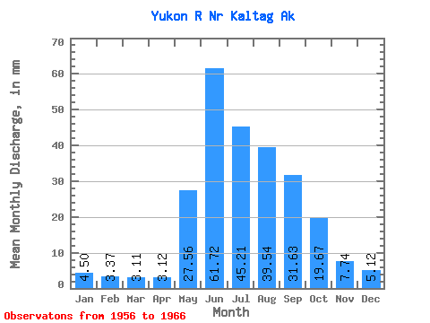
| Statistic | Jan | Feb | Mar | Apr | May | Jun | Jul | Aug | Sep | Oct | Nov | Dec | Annual |
|---|---|---|---|---|---|---|---|---|---|---|---|---|---|
| Mean | 4.50 | 3.40 | 3.11 | 3.12 | 27.55 | 61.72 | 45.21 | 39.53 | 31.63 | 19.66 | 7.74 | 5.12 | 256.87 |
| Standard Deviation | 0.83 | 0.56 | 0.66 | 0.49 | 11.45 | 15.96 | 11.07 | 10.40 | 8.52 | 4.87 | 2.13 | 1.08 | 44.91 |
| Min | 3.46 | 2.52 | 1.98 | 2.06 | 12.24 | 40.70 | 29.35 | 25.35 | 17.51 | 11.19 | 5.55 | 3.90 | 182.96 |
| Max | 6.03 | 4.33 | 3.96 | 3.73 | 46.62 | 90.26 | 63.57 | 58.31 | 45.68 | 26.79 | 12.45 | 7.42 | 324.36 |
| Coefficient of Variation | 0.18 | 0.17 | 0.21 | 0.16 | 0.42 | 0.26 | 0.24 | 0.26 | 0.27 | 0.25 | 0.28 | 0.21 | 0.17 |
 Return to R-Arctic Net Home Page