|
|
|||||||||||||||||
| Point ID: 7701 | Downloads | Plots | Site Data | Code: 15493500 |
|
|
|||||||||||||||||
| Download | |
|---|---|
| Site Descriptor Information | Site Time Series Data |
| Link to all available data | |
| View: | Time Series | All |
| Units: | m3/s |
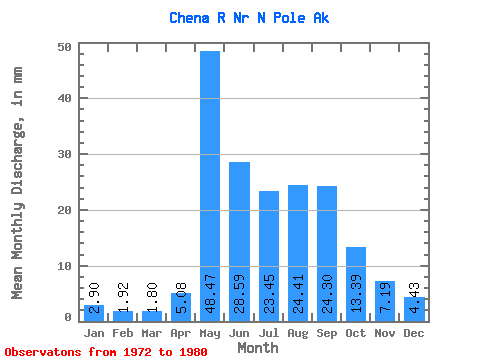
| Statistic | Jan | Feb | Mar | Apr | May | Jun | Jul | Aug | Sep | Oct | Nov | Dec | Annual |
|---|---|---|---|---|---|---|---|---|---|---|---|---|---|
| Mean | 2.90 | 1.94 | 1.80 | 5.08 | 48.46 | 28.59 | 23.45 | 24.41 | 24.30 | 13.39 | 7.19 | 4.43 | 175.35 |
| Standard Deviation | 0.97 | 0.67 | 0.64 | 2.65 | 21.89 | 14.00 | 8.31 | 11.45 | 9.38 | 5.05 | 2.58 | 1.50 | 51.51 |
| Min | 1.43 | 1.29 | 1.08 | 1.82 | 17.08 | 15.30 | 11.25 | 11.79 | 10.85 | 8.02 | 4.61 | 2.80 | 118.97 |
| Max | 4.90 | 3.32 | 2.94 | 8.85 | 83.70 | 55.21 | 36.25 | 48.24 | 38.91 | 21.30 | 12.59 | 7.86 | 237.60 |
| Coefficient of Variation | 0.34 | 0.34 | 0.36 | 0.52 | 0.45 | 0.49 | 0.35 | 0.47 | 0.39 | 0.38 | 0.36 | 0.34 | 0.29 |
 Return to R-Arctic Net Home Page