|
|
|||||||||||||||||
| Point ID: 7697 | Downloads | Plots | Site Data | Code: 15468000 |
|
|
|||||||||||||||||
| Download | |
|---|---|
| Site Descriptor Information | Site Time Series Data |
| Link to all available data | |
| View: | Time Series | All |
| Units: | m3/s |
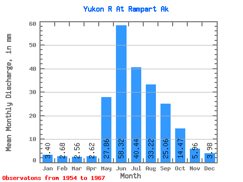
| Statistic | Jan | Feb | Mar | Apr | May | Jun | Jul | Aug | Sep | Oct | Nov | Dec | Annual |
|---|---|---|---|---|---|---|---|---|---|---|---|---|---|
| Mean | 3.40 | 2.71 | 2.56 | 2.62 | 27.85 | 58.31 | 40.43 | 33.21 | 25.06 | 14.46 | 5.96 | 3.98 | 220.33 |
| Standard Deviation | 0.74 | 0.62 | 0.65 | 0.61 | 7.63 | 21.29 | 10.91 | 7.94 | 5.55 | 3.21 | 1.37 | 0.83 | 47.75 |
| Min | 2.20 | 1.47 | 1.32 | 1.28 | 12.46 | 35.62 | 24.55 | 20.23 | 16.03 | 8.85 | 4.41 | 2.71 | 154.92 |
| Max | 4.70 | 3.75 | 3.67 | 3.84 | 39.38 | 110.54 | 63.70 | 42.72 | 35.56 | 18.68 | 9.24 | 5.73 | 297.61 |
| Coefficient of Variation | 0.22 | 0.23 | 0.25 | 0.23 | 0.27 | 0.36 | 0.27 | 0.24 | 0.22 | 0.22 | 0.23 | 0.21 | 0.22 |
 Return to R-Arctic Net Home Page