|
|
|||||||||||||||||
| Point ID: 7692 | Downloads | Plots | Site Data | Code: 05057000 |
|
|
|||||||||||||||||
| Download | |
|---|---|
| Site Descriptor Information | Site Time Series Data |
| Link to all available data | |
| View: | Time Series | All |
| Units: | m3/s |
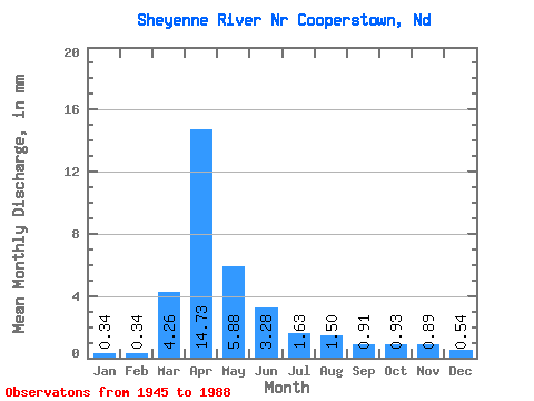
| Statistic | Jan | Feb | Mar | Apr | May | Jun | Jul | Aug | Sep | Oct | Nov | Dec | Annual |
|---|---|---|---|---|---|---|---|---|---|---|---|---|---|
| Mean | 0.07 | 0.07 | 0.84 | 2.89 | 1.15 | 0.64 | 0.32 | 0.29 | 0.18 | 0.18 | 0.17 | 0.10 | 7.21 |
| Standard Deviation | 0.06 | 0.08 | 1.22 | 2.87 | 1.50 | 0.63 | 0.27 | 0.65 | 0.29 | 0.27 | 0.26 | 0.11 | 5.49 |
| Min | 0.01 | 0.00 | 0.01 | 0.19 | 0.17 | 0.03 | 0.02 | 0.00 | 0.00 | 0.00 | 0.01 | 0.01 | 0.82 |
| Max | 0.31 | 0.46 | 6.25 | 11.49 | 8.84 | 3.83 | 1.04 | 4.67 | 1.41 | 1.77 | 1.64 | 0.65 | 21.34 |
| Coefficient of Variation | 0.90 | 1.21 | 1.46 | 0.99 | 1.30 | 0.98 | 0.85 | 2.21 | 1.65 | 1.45 | 1.47 | 1.07 | 0.76 |
 Return to R-Arctic Net Home Page