|
|
|||||||||||||||||
| Point ID: 7688 | Downloads | Plots | Site Data | Code: 15744500 |
|
|
|||||||||||||||||
| Download | |
|---|---|
| Site Descriptor Information | Site Time Series Data |
| Link to all available data | |
| View: | Time Series | All |
| Units: | m3/s |
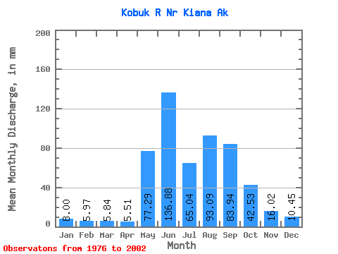
| Statistic | Jan | Feb | Mar | Apr | May | Jun | Jul | Aug | Sep | Oct | Nov | Dec | Annual |
|---|---|---|---|---|---|---|---|---|---|---|---|---|---|
| Mean | 8.00 | 6.03 | 5.84 | 5.51 | 77.28 | 136.88 | 65.03 | 93.07 | 83.94 | 42.53 | 16.02 | 10.45 | 543.69 |
| Standard Deviation | 1.93 | 1.30 | 1.18 | 1.62 | 51.95 | 59.12 | 27.38 | 54.67 | 49.16 | 18.85 | 5.90 | 3.13 | 138.38 |
| Min | 4.94 | 3.73 | 3.43 | 2.98 | 5.03 | 58.62 | 27.78 | 24.02 | 28.40 | 15.39 | 8.18 | 5.92 | 369.95 |
| Max | 12.19 | 8.03 | 7.99 | 11.02 | 160.68 | 258.85 | 123.35 | 240.39 | 232.62 | 91.81 | 32.87 | 18.74 | 831.91 |
| Coefficient of Variation | 0.24 | 0.22 | 0.20 | 0.29 | 0.67 | 0.43 | 0.42 | 0.59 | 0.59 | 0.44 | 0.37 | 0.30 | 0.26 |
 Return to R-Arctic Net Home Page