|
|
|||||||||||||||||
| Point ID: 7686 | Downloads | Plots | Site Data | Code: 15564600 |
|
|
|||||||||||||||||
| Download | |
|---|---|
| Site Descriptor Information | Site Time Series Data |
| Link to all available data | |
| View: | Time Series | All |
| Units: | m3/s |
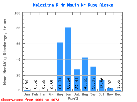
| Statistic | Jan | Feb | Mar | Apr | May | Jun | Jul | Aug | Sep | Oct | Nov | Dec | Annual |
|---|---|---|---|---|---|---|---|---|---|---|---|---|---|
| Mean | 0.96 | 0.62 | 0.56 | 0.65 | 61.30 | 80.64 | 27.41 | 42.61 | 30.96 | 13.66 | 3.92 | 1.66 | 259.88 |
| Standard Deviation | 0.77 | 0.51 | 0.42 | 0.38 | 40.01 | 35.24 | 13.57 | 35.17 | 22.21 | 10.80 | 2.17 | 0.97 | 95.38 |
| Min | 0.00 | 0.00 | 0.00 | 0.04 | 1.47 | 8.94 | 5.90 | 8.49 | 6.06 | 3.52 | 0.87 | 0.23 | 73.46 |
| Max | 2.61 | 1.68 | 1.30 | 1.37 | 132.24 | 118.11 | 54.00 | 115.40 | 76.93 | 44.68 | 8.62 | 3.69 | 387.98 |
| Coefficient of Variation | 0.80 | 0.82 | 0.74 | 0.58 | 0.65 | 0.44 | 0.49 | 0.82 | 0.72 | 0.79 | 0.55 | 0.58 | 0.37 |
 Return to R-Arctic Net Home Page