|
|
|||||||||||||||||
| Point ID: 7677 | Downloads | Plots | Site Data | Code: 15348000 |
|
|
|||||||||||||||||
| Download | |
|---|---|
| Site Descriptor Information | Site Time Series Data |
| Link to all available data | |
| View: | Time Series | All |
| Units: | m3/s |
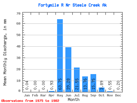
| Statistic | Jan | Feb | Mar | Apr | May | Jun | Jul | Aug | Sep | Oct | Nov | Dec | Annual |
|---|---|---|---|---|---|---|---|---|---|---|---|---|---|
| Mean | 0.04 | 0.00 | 0.00 | 0.93 | 63.74 | 39.28 | 21.54 | 13.76 | 15.75 | 3.89 | 0.55 | 0.20 | 148.78 |
| Standard Deviation | 0.04 | 0.00 | 0.00 | 1.73 | 21.90 | 21.77 | 8.08 | 9.08 | 14.25 | 2.35 | 0.61 | 0.23 | 49.05 |
| Min | 0.00 | 0.00 | 0.00 | 0.01 | 34.66 | 19.21 | 8.98 | 4.49 | 4.53 | 1.29 | 0.02 | 0.00 | 92.28 |
| Max | 0.09 | 0.01 | 0.01 | 4.77 | 95.55 | 81.45 | 29.99 | 29.93 | 45.93 | 8.31 | 1.50 | 0.48 | 231.01 |
| Coefficient of Variation | 1.14 | 2.65 | 2.65 | 1.87 | 0.34 | 0.55 | 0.38 | 0.66 | 0.91 | 0.60 | 1.11 | 1.10 | 0.33 |
 Return to R-Arctic Net Home Page