|
|
|||||||||||||||||
| Point ID: 7672 | Downloads | Plots | Site Data | Code: 71293 |
|
|
|||||||||||||||||
| Download | |
|---|---|
| Site Descriptor Information | Site Time Series Data |
| Link to all available data | |
| View: | Time Series | All |
| Units: | m3/s |
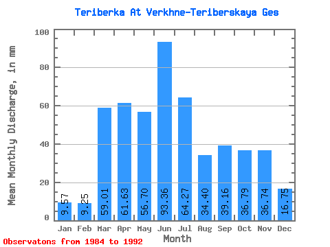
| Statistic | Jan | Feb | Mar | Apr | May | Jun | Jul | Aug | Sep | Oct | Nov | Dec | Annual |
|---|---|---|---|---|---|---|---|---|---|---|---|---|---|
| Mean | 9.57 | 9.33 | 59.00 | 61.63 | 56.69 | 93.36 | 64.27 | 34.40 | 39.16 | 36.78 | 36.74 | 16.74 | 517.52 |
| Standard Deviation | 7.88 | 8.63 | 14.95 | 28.41 | 37.56 | 43.30 | 32.05 | 20.48 | 19.83 | 30.71 | 31.00 | 13.36 | 117.90 |
| Min | 1.40 | 0.88 | 31.52 | 19.98 | 12.93 | 10.99 | 17.71 | 1.40 | 2.75 | 0.52 | 1.35 | 1.72 | 309.49 |
| Max | 22.32 | 26.94 | 78.39 | 96.25 | 125.39 | 136.35 | 114.93 | 70.44 | 72.36 | 91.50 | 89.23 | 47.84 | 645.32 |
| Coefficient of Variation | 0.82 | 0.93 | 0.25 | 0.46 | 0.66 | 0.46 | 0.50 | 0.59 | 0.51 | 0.83 | 0.84 | 0.80 | 0.23 |
 Return to R-Arctic Net Home Page