|
|
|||||||||||||||||
| Point ID: 7661 | Downloads | Plots | Site Data | Code: 71265 |
|
|
|||||||||||||||||
| Download | |
|---|---|
| Site Descriptor Information | Site Time Series Data |
| Link to all available data | |
| View: | Time Series | All |
| Units: | m3/s |
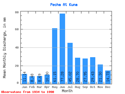
| Statistic | Jan | Feb | Mar | Apr | May | Jun | Jul | Aug | Sep | Oct | Nov | Dec | Annual |
|---|---|---|---|---|---|---|---|---|---|---|---|---|---|
| Mean | 11.13 | 8.55 | 8.69 | 10.30 | 61.14 | 77.28 | 45.01 | 28.70 | 27.95 | 29.42 | 21.30 | 14.72 | 345.12 |
| Standard Deviation | 2.43 | 1.77 | 1.77 | 6.72 | 33.69 | 29.51 | 25.32 | 16.30 | 14.43 | 10.85 | 8.13 | 4.33 | 71.60 |
| Min | 6.37 | 4.52 | 4.42 | 5.18 | 14.93 | 23.20 | 15.01 | 9.54 | 12.07 | 12.43 | 9.61 | 7.19 | 177.00 |
| Max | 17.52 | 13.11 | 13.41 | 51.46 | 141.52 | 146.44 | 161.07 | 81.71 | 91.57 | 59.81 | 54.49 | 34.17 | 547.54 |
| Coefficient of Variation | 0.22 | 0.21 | 0.20 | 0.65 | 0.55 | 0.38 | 0.56 | 0.57 | 0.52 | 0.37 | 0.38 | 0.29 | 0.21 |
 Return to R-Arctic Net Home Page