|
|
|||||||||||||||||
| Point ID: 7654 | Downloads | Plots | Site Data | Code: 71241 |
|
|
|||||||||||||||||
| Download | |
|---|---|
| Site Descriptor Information | Site Time Series Data |
| Link to all available data | |
| View: | Time Series | All |
| Units: | m3/s |
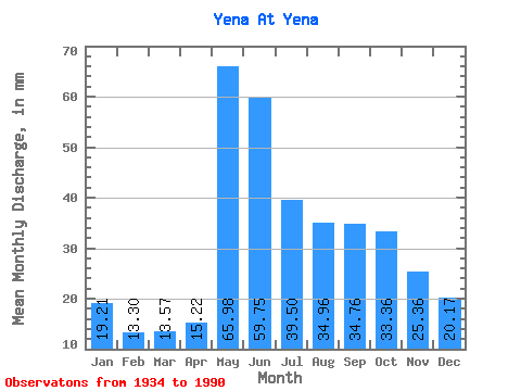
| Statistic | Jan | Feb | Mar | Apr | May | Jun | Jul | Aug | Sep | Oct | Nov | Dec | Annual |
|---|---|---|---|---|---|---|---|---|---|---|---|---|---|
| Mean | 19.21 | 13.42 | 13.56 | 15.22 | 65.97 | 59.75 | 39.49 | 34.95 | 34.76 | 33.36 | 25.36 | 20.16 | 374.25 |
| Standard Deviation | 20.74 | 2.02 | 1.69 | 4.75 | 22.97 | 22.44 | 14.88 | 12.05 | 9.49 | 8.45 | 7.03 | 4.23 | 68.67 |
| Min | 8.60 | 7.77 | 8.96 | 9.65 | 33.06 | 23.52 | 16.00 | 15.42 | 18.88 | 17.69 | 10.64 | 9.37 | 226.47 |
| Max | 170.27 | 17.32 | 16.12 | 33.76 | 114.23 | 114.40 | 87.78 | 67.11 | 56.48 | 55.71 | 44.80 | 29.09 | 502.48 |
| Coefficient of Variation | 1.08 | 0.15 | 0.12 | 0.31 | 0.35 | 0.38 | 0.38 | 0.34 | 0.27 | 0.25 | 0.28 | 0.21 | 0.18 |
 Return to R-Arctic Net Home Page