|
|
|||||||||||||||||
| Point ID: 7643 | Downloads | Plots | Site Data | Code: 71199 |
|
|
|||||||||||||||||
| Download | |
|---|---|
| Site Descriptor Information | Site Time Series Data |
| Link to all available data | |
| View: | Time Series | All |
| Units: | m3/s |
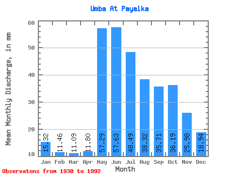
| Statistic | Jan | Feb | Mar | Apr | May | Jun | Jul | Aug | Sep | Oct | Nov | Dec | Annual |
|---|---|---|---|---|---|---|---|---|---|---|---|---|---|
| Mean | 15.32 | 11.56 | 11.09 | 11.80 | 57.28 | 57.63 | 48.48 | 38.31 | 35.71 | 36.18 | 25.98 | 18.94 | 364.19 |
| Standard Deviation | 3.67 | 2.73 | 2.60 | 3.82 | 21.30 | 16.78 | 12.87 | 11.26 | 12.17 | 13.35 | 9.11 | 4.69 | 73.41 |
| Min | 7.70 | 6.35 | 6.08 | 6.25 | 9.29 | 23.45 | 19.97 | 17.84 | 15.21 | 13.93 | 8.28 | 8.01 | 192.80 |
| Max | 23.99 | 18.48 | 17.96 | 25.32 | 98.30 | 94.39 | 76.62 | 63.47 | 67.80 | 95.97 | 47.95 | 30.30 | 563.74 |
| Coefficient of Variation | 0.24 | 0.24 | 0.23 | 0.32 | 0.37 | 0.29 | 0.27 | 0.29 | 0.34 | 0.37 | 0.35 | 0.25 | 0.20 |
 Return to R-Arctic Net Home Page