|
|
|||||||||||||||||
| Point ID: 7633 | Downloads | Plots | Site Data | Code: 71176 |
|
|
|||||||||||||||||
| Download | |
|---|---|
| Site Descriptor Information | Site Time Series Data |
| Link to all available data | |
| View: | Time Series | All |
| Units: | m3/s |
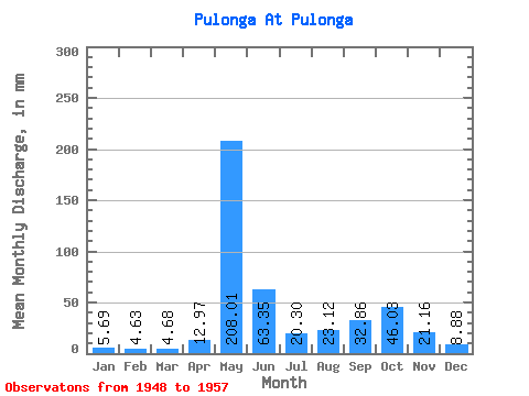
| Statistic | Jan | Feb | Mar | Apr | May | Jun | Jul | Aug | Sep | Oct | Nov | Dec | Annual |
|---|---|---|---|---|---|---|---|---|---|---|---|---|---|
| Mean | 5.69 | 4.67 | 4.68 | 12.97 | 207.98 | 63.35 | 20.30 | 23.11 | 32.86 | 46.02 | 21.16 | 8.88 | 438.88 |
| Standard Deviation | 2.04 | 1.52 | 1.55 | 20.13 | 56.34 | 35.28 | 10.98 | 19.57 | 24.22 | 28.20 | 15.16 | 3.78 | 85.44 |
| Min | 4.12 | 3.21 | 3.16 | 2.52 | 127.50 | 31.65 | 9.55 | 6.24 | 7.74 | 21.62 | 8.24 | 4.84 | 328.44 |
| Max | 9.27 | 8.19 | 8.27 | 64.61 | 266.60 | 137.72 | 41.17 | 66.35 | 87.05 | 100.72 | 46.81 | 17.35 | 603.05 |
| Coefficient of Variation | 0.36 | 0.33 | 0.33 | 1.55 | 0.27 | 0.56 | 0.54 | 0.85 | 0.74 | 0.61 | 0.72 | 0.43 | 0.20 |
 Return to R-Arctic Net Home Page