|
|
|||||||||||||||||
| Point ID: 763 | Downloads | Plots | Site Data | Code: 07GF007 |
|
|
|||||||||||||||||
| Download | |
|---|---|
| Site Descriptor Information | Site Time Series Data |
| Link to all available data | |
| View: | Time Series | All |
| Units: | m3/s |
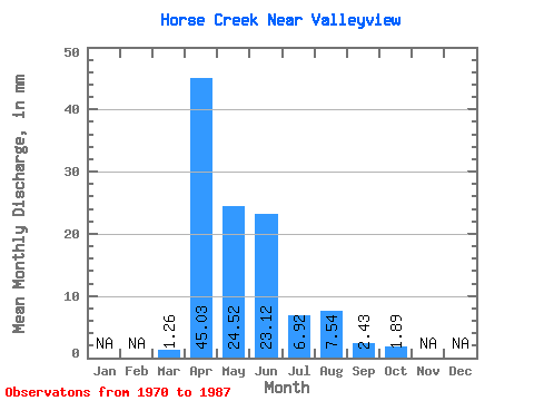
| Statistic | Jan | Feb | Mar | Apr | May | Jun | Jul | Aug | Sep | Oct | Nov | Dec | Annual |
|---|---|---|---|---|---|---|---|---|---|---|---|---|---|
| Mean | 1.01 | 45.21 | 24.45 | 23.23 | 7.06 | 7.66 | 2.27 | 2.18 | |||||
| Standard Deviation | 2.25 | 43.31 | 24.62 | 30.24 | 8.93 | 24.41 | 2.99 | 2.54 | |||||
| Min | 0.00 | 5.48 | 1.89 | 0.61 | 0.00 | 0.00 | 0.00 | 0.00 | |||||
| Max | 5.03 | 163.67 | 73.55 | 103.44 | 33.95 | 101.21 | 9.73 | 8.17 | |||||
| Coefficient of Variation | 2.24 | 0.96 | 1.01 | 1.30 | 1.27 | 3.19 | 1.32 | 1.16 |
 Return to R-Arctic Net Home Page