|
|
|||||||||||||||||
| Point ID: 7603 | Downloads | Plots | Site Data | Code: 71117 |
|
|
|||||||||||||||||
| Download | |
|---|---|
| Site Descriptor Information | Site Time Series Data |
| Link to all available data | |
| View: | Time Series | All |
| Units: | m3/s |
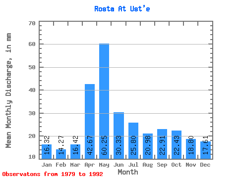
| Statistic | Jan | Feb | Mar | Apr | May | Jun | Jul | Aug | Sep | Oct | Nov | Dec | Annual |
|---|---|---|---|---|---|---|---|---|---|---|---|---|---|
| Mean | 16.31 | 14.39 | 16.40 | 42.67 | 60.25 | 30.35 | 25.78 | 20.96 | 22.91 | 22.45 | 18.82 | 17.60 | 314.71 |
| Standard Deviation | 6.43 | 5.76 | 6.27 | 27.72 | 22.04 | 11.61 | 12.20 | 9.36 | 11.72 | 10.30 | 8.80 | 8.59 | 86.36 |
| Min | 9.38 | 7.74 | 9.53 | 14.19 | 31.86 | 18.30 | 10.36 | 10.15 | 9.63 | 11.24 | 9.07 | 10.15 | 195.95 |
| Max | 28.49 | 25.01 | 29.52 | 104.28 | 95.83 | 51.14 | 47.66 | 45.58 | 52.14 | 49.73 | 37.10 | 38.33 | 450.71 |
| Coefficient of Variation | 0.39 | 0.40 | 0.38 | 0.65 | 0.37 | 0.38 | 0.47 | 0.45 | 0.51 | 0.46 | 0.47 | 0.49 | 0.27 |
 Return to R-Arctic Net Home Page