|
|
|||||||||||||||||
| Point ID: 759 | Downloads | Plots | Site Data | Code: 07GF003 |
|
|
|||||||||||||||||
| Download | |
|---|---|
| Site Descriptor Information | Site Time Series Data |
| Link to all available data | |
| View: | Time Series | All |
| Units: | m3/s |
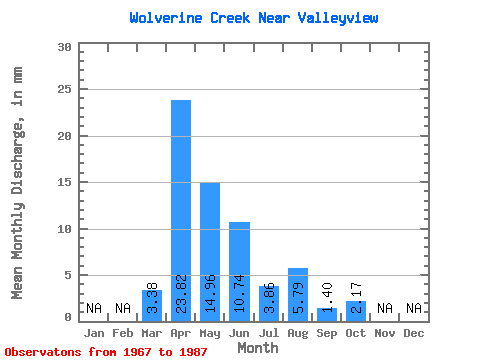
| Statistic | Jan | Feb | Mar | Apr | May | Jun | Jul | Aug | Sep | Oct | Nov | Dec | Annual |
|---|---|---|---|---|---|---|---|---|---|---|---|---|---|
| Mean | 3.38 | 23.90 | 15.04 | 10.81 | 3.89 | 5.69 | 1.37 | 2.14 | |||||
| Standard Deviation | 6.88 | 19.91 | 14.94 | 14.04 | 5.08 | 16.20 | 1.73 | 2.91 | |||||
| Min | 0.00 | 2.80 | 0.72 | 0.00 | 0.00 | 0.00 | 0.00 | 0.00 | |||||
| Max | 17.37 | 76.83 | 48.25 | 48.80 | 17.85 | 71.41 | 7.00 | 10.86 | |||||
| Coefficient of Variation | 2.04 | 0.83 | 0.99 | 1.30 | 1.31 | 2.85 | 1.27 | 1.36 |
 Return to R-Arctic Net Home Page