|
|
|||||||||||||||||
| Point ID: 7586 | Downloads | Plots | Site Data | Code: 71068 |
|
|
|||||||||||||||||
| Download | |
|---|---|
| Site Descriptor Information | Site Time Series Data |
| Link to all available data | |
| View: | Time Series | All |
| Units: | m3/s |
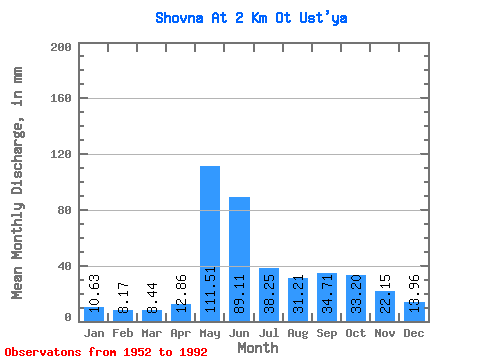
| Statistic | Jan | Feb | Mar | Apr | May | Jun | Jul | Aug | Sep | Oct | Nov | Dec | Annual |
|---|---|---|---|---|---|---|---|---|---|---|---|---|---|
| Mean | 10.63 | 8.24 | 8.44 | 12.87 | 111.49 | 89.11 | 38.24 | 31.21 | 34.71 | 33.19 | 22.15 | 13.95 | 412.78 |
| Standard Deviation | 2.06 | 1.81 | 1.75 | 8.97 | 50.12 | 42.15 | 19.96 | 18.27 | 16.08 | 11.07 | 9.60 | 3.44 | 85.75 |
| Min | 5.48 | 3.17 | 6.01 | 5.92 | 25.20 | 28.88 | 12.65 | 9.54 | 13.62 | 10.44 | 4.95 | 3.48 | 224.33 |
| Max | 15.55 | 14.65 | 14.29 | 46.79 | 228.26 | 184.71 | 101.22 | 82.24 | 87.76 | 61.15 | 61.74 | 19.66 | 579.74 |
| Coefficient of Variation | 0.19 | 0.22 | 0.21 | 0.70 | 0.45 | 0.47 | 0.52 | 0.59 | 0.46 | 0.33 | 0.43 | 0.25 | 0.21 |
 Return to R-Arctic Net Home Page