|
|
|||||||||||||||||
| Point ID: 7570 | Downloads | Plots | Site Data | Code: 71002 |
|
|
|||||||||||||||||
| Download | |
|---|---|
| Site Descriptor Information | Site Time Series Data |
| Link to all available data | |
| View: | Time Series | All |
| Units: | m3/s |
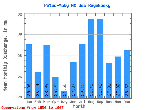
| Statistic | Jan | Feb | Mar | Apr | May | Jun | Jul | Aug | Sep | Oct | Nov | Dec | Annual |
|---|---|---|---|---|---|---|---|---|---|---|---|---|---|
| Mean | 29.05 | 26.67 | 28.99 | 26.01 | 24.68 | 27.37 | 29.12 | 31.43 | 31.43 | 27.31 | 27.92 | 28.52 | 338.66 |
| Standard Deviation | 7.26 | 6.69 | 7.87 | 8.68 | 7.79 | 6.04 | 9.72 | 12.73 | 15.01 | 7.58 | 7.54 | 6.47 | 76.65 |
| Min | 10.97 | 11.05 | 14.64 | 14.98 | 12.23 | 20.42 | 19.99 | 21.28 | 17.17 | 14.58 | 11.22 | 11.68 | 226.85 |
| Max | 37.05 | 34.43 | 40.35 | 39.06 | 36.50 | 40.83 | 54.48 | 66.03 | 61.43 | 43.84 | 39.59 | 33.02 | 466.56 |
| Coefficient of Variation | 0.25 | 0.25 | 0.27 | 0.33 | 0.32 | 0.22 | 0.33 | 0.41 | 0.48 | 0.28 | 0.27 | 0.23 | 0.23 |
 Return to R-Arctic Net Home Page