|
|
|||||||||||||||||
| Point ID: 755 | Downloads | Plots | Site Data | Code: 07GE006 |
|
|
|||||||||||||||||
| Download | |
|---|---|
| Site Descriptor Information | Site Time Series Data |
| Link to all available data | |
| View: | Time Series | All |
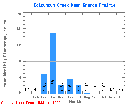
| Units: | m3/s |
| Statistic | Jan | Feb | Mar | Apr | May | Jun | Jul | Aug | Sep | Oct | Nov | Dec | Annual |
|---|---|---|---|---|---|---|---|---|---|---|---|---|---|
| Mean | 4.39 | 13.40 | 1.84 | 3.25 | 1.87 | 0.14 | 0.05 | 0.03 | |||||
| Standard Deviation | 4.63 | 17.50 | 2.82 | 6.39 | 4.13 | 0.38 | 0.08 | 0.05 | |||||
| Min | 0.00 | 0.66 | 0.04 | 0.00 | 0.00 | 0.00 | 0.00 | 0.00 | |||||
| Max | 13.66 | 53.04 | 7.97 | 23.33 | 14.07 | 1.40 | 0.28 | 0.17 | |||||
| Coefficient of Variation | 1.05 | 1.31 | 1.53 | 1.97 | 2.21 | 2.71 | 1.64 | 1.71 |
 Return to R-Arctic Net Home Page