|
|
|||||||||||||||||
| Point ID: 7540 | Downloads | Plots | Site Data | Code: 70576 |
|
|
|||||||||||||||||
| Download | |
|---|---|
| Site Descriptor Information | Site Time Series Data |
| Link to all available data | |
| View: | Time Series | All |
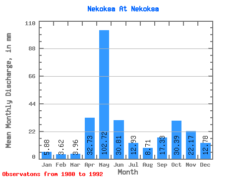
| Units: | m3/s |
| Statistic | Jan | Feb | Mar | Apr | May | Jun | Jul | Aug | Sep | Oct | Nov | Dec | Annual |
|---|---|---|---|---|---|---|---|---|---|---|---|---|---|
| Mean | 5.88 | 3.65 | 3.96 | 32.73 | 102.70 | 30.80 | 12.93 | 8.71 | 17.34 | 30.39 | 22.17 | 12.79 | 289.45 |
| Standard Deviation | 3.30 | 1.56 | 2.20 | 32.67 | 31.52 | 16.46 | 9.45 | 7.44 | 11.03 | 24.85 | 13.53 | 9.06 | 50.01 |
| Min | 2.75 | 1.17 | 1.55 | 2.45 | 66.02 | 8.39 | 3.54 | 2.56 | 2.25 | 3.09 | 2.77 | 3.02 | 234.14 |
| Max | 13.03 | 6.50 | 9.60 | 91.48 | 154.66 | 55.86 | 32.08 | 29.07 | 37.98 | 95.95 | 46.43 | 32.08 | 408.63 |
| Coefficient of Variation | 0.56 | 0.43 | 0.56 | 1.00 | 0.31 | 0.53 | 0.73 | 0.85 | 0.64 | 0.82 | 0.61 | 0.71 | 0.17 |
 Return to R-Arctic Net Home Page