|
|
|||||||||||||||||
| Point ID: 753 | Downloads | Plots | Site Data | Code: 07GE003 |
|
|
|||||||||||||||||
| Download | |
|---|---|
| Site Descriptor Information | Site Time Series Data |
| Link to all available data | |
| View: | Time Series | All |
| Units: | m3/s |
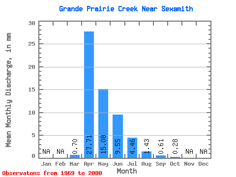
| Statistic | Jan | Feb | Mar | Apr | May | Jun | Jul | Aug | Sep | Oct | Nov | Dec | Annual |
|---|---|---|---|---|---|---|---|---|---|---|---|---|---|
| Mean | 0.70 | 27.71 | 15.08 | 9.55 | 4.45 | 1.42 | 0.61 | 0.29 | |||||
| Standard Deviation | 2.02 | 25.89 | 15.88 | 16.95 | 9.73 | 4.94 | 1.82 | 0.70 | |||||
| Min | 0.00 | 0.56 | 0.02 | 0.10 | 0.00 | 0.00 | 0.00 | 0.00 | |||||
| Max | 10.77 | 92.94 | 54.09 | 77.59 | 48.80 | 25.19 | 8.39 | 3.10 | |||||
| Coefficient of Variation | 2.90 | 0.93 | 1.05 | 1.77 | 2.19 | 3.47 | 2.98 | 2.44 |
 Return to R-Arctic Net Home Page