|
|
|||||||||||||||||
| Point ID: 7522 | Downloads | Plots | Site Data | Code: 70535 |
|
|
|||||||||||||||||
| Download | |
|---|---|
| Site Descriptor Information | Site Time Series Data |
| Link to all available data | |
| View: | Time Series | All |
| Units: | m3/s |
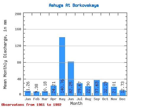
| Statistic | Jan | Feb | Mar | Apr | May | Jun | Jul | Aug | Sep | Oct | Nov | Dec | Annual |
|---|---|---|---|---|---|---|---|---|---|---|---|---|---|
| Mean | 11.27 | 9.46 | 10.18 | 24.22 | 140.74 | 82.25 | 29.66 | 22.90 | 37.64 | 32.18 | 21.00 | 12.73 | 443.45 |
| Standard Deviation | 3.28 | 2.50 | 1.76 | 31.28 | 61.06 | 62.67 | 24.05 | 11.96 | 18.07 | 13.92 | 11.00 | 2.85 | 84.37 |
| Min | 6.62 | 4.68 | 7.18 | 6.86 | 17.36 | 16.62 | 11.01 | 10.45 | 12.19 | 15.77 | 11.02 | 9.14 | 255.03 |
| Max | 24.54 | 18.45 | 14.00 | 162.56 | 251.00 | 265.52 | 108.24 | 54.59 | 74.51 | 63.92 | 51.03 | 21.00 | 564.85 |
| Coefficient of Variation | 0.29 | 0.27 | 0.17 | 1.29 | 0.43 | 0.76 | 0.81 | 0.52 | 0.48 | 0.43 | 0.52 | 0.22 | 0.19 |
 Return to R-Arctic Net Home Page