|
|
|||||||||||||||||
| Point ID: 7518 | Downloads | Plots | Site Data | Code: 70530 |
|
|
|||||||||||||||||
| Download | |
|---|---|
| Site Descriptor Information | Site Time Series Data |
| Link to all available data | |
| View: | Time Series | All |
| Units: | m3/s |
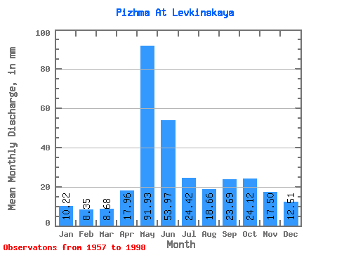
| Statistic | Jan | Feb | Mar | Apr | May | Jun | Jul | Aug | Sep | Oct | Nov | Dec | Annual |
|---|---|---|---|---|---|---|---|---|---|---|---|---|---|
| Mean | 10.21 | 8.42 | 8.68 | 17.96 | 91.92 | 53.97 | 24.41 | 18.66 | 23.69 | 24.11 | 17.50 | 12.51 | 309.67 |
| Standard Deviation | 1.53 | 1.21 | 1.62 | 18.23 | 28.90 | 28.46 | 9.08 | 7.26 | 9.76 | 8.19 | 6.87 | 3.05 | 51.91 |
| Min | 7.12 | 6.27 | 1.61 | 6.65 | 41.06 | 16.47 | 12.26 | 10.78 | 11.22 | 10.71 | 7.86 | 8.38 | 228.87 |
| Max | 13.93 | 12.15 | 11.77 | 84.21 | 176.15 | 168.19 | 52.85 | 43.92 | 44.58 | 41.30 | 39.63 | 26.78 | 440.55 |
| Coefficient of Variation | 0.15 | 0.14 | 0.19 | 1.01 | 0.31 | 0.53 | 0.37 | 0.39 | 0.41 | 0.34 | 0.39 | 0.24 | 0.17 |
 Return to R-Arctic Net Home Page