|
|
|||||||||||||||||
| Point ID: 7516 | Downloads | Plots | Site Data | Code: 70525 |
|
|
|||||||||||||||||
| Download | |
|---|---|
| Site Descriptor Information | Site Time Series Data |
| Link to all available data | |
| View: | Time Series | All |
| Units: | m3/s |
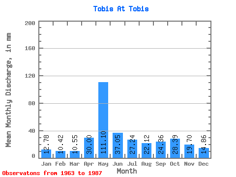
| Statistic | Jan | Feb | Mar | Apr | May | Jun | Jul | Aug | Sep | Oct | Nov | Dec | Annual |
|---|---|---|---|---|---|---|---|---|---|---|---|---|---|
| Mean | 12.78 | 10.52 | 10.55 | 30.00 | 111.08 | 37.05 | 27.23 | 22.12 | 24.36 | 28.39 | 19.70 | 14.86 | 346.98 |
| Standard Deviation | 2.26 | 1.51 | 1.36 | 30.06 | 32.29 | 14.49 | 13.39 | 10.28 | 7.72 | 8.75 | 4.94 | 4.18 | 49.36 |
| Min | 9.34 | 8.29 | 8.76 | 8.77 | 60.77 | 17.05 | 12.09 | 12.60 | 14.12 | 18.92 | 13.62 | 1.74 | 269.94 |
| Max | 20.02 | 15.52 | 15.55 | 130.93 | 161.71 | 76.10 | 63.17 | 50.47 | 41.54 | 57.34 | 32.77 | 27.54 | 445.08 |
| Coefficient of Variation | 0.18 | 0.14 | 0.13 | 1.00 | 0.29 | 0.39 | 0.49 | 0.47 | 0.32 | 0.31 | 0.25 | 0.28 | 0.14 |
 Return to R-Arctic Net Home Page