|
|
|||||||||||||||||
| Point ID: 7491 | Downloads | Plots | Site Data | Code: 70452 |
|
|
|||||||||||||||||
| Download | |
|---|---|
| Site Descriptor Information | Site Time Series Data |
| Link to all available data | |
| View: | Time Series | All |
| Units: | m3/s |
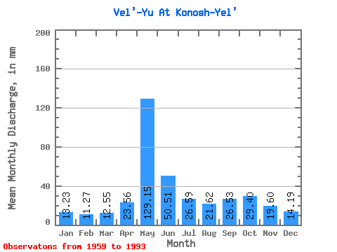
| Statistic | Jan | Feb | Mar | Apr | May | Jun | Jul | Aug | Sep | Oct | Nov | Dec | Annual |
|---|---|---|---|---|---|---|---|---|---|---|---|---|---|
| Mean | 13.23 | 11.37 | 12.54 | 23.56 | 129.13 | 50.51 | 26.59 | 21.62 | 26.53 | 29.40 | 19.60 | 14.19 | 374.05 |
| Standard Deviation | 2.10 | 2.03 | 1.88 | 18.82 | 34.22 | 24.74 | 13.70 | 8.65 | 8.57 | 10.02 | 6.28 | 2.58 | 54.47 |
| Min | 5.96 | 3.32 | 6.96 | 10.76 | 45.85 | 23.14 | 13.59 | 11.34 | 13.91 | 14.24 | 11.71 | 8.22 | 279.11 |
| Max | 18.55 | 15.35 | 16.59 | 93.19 | 205.10 | 114.81 | 73.16 | 53.17 | 55.38 | 54.74 | 37.93 | 20.12 | 504.82 |
| Coefficient of Variation | 0.16 | 0.18 | 0.15 | 0.80 | 0.27 | 0.49 | 0.52 | 0.40 | 0.32 | 0.34 | 0.32 | 0.18 | 0.15 |
 Return to R-Arctic Net Home Page