|
|
|||||||||||||||||
| Point ID: 7457 | Downloads | Plots | Site Data | Code: 70360 |
|
|
|||||||||||||||||
| Download | |
|---|---|
| Site Descriptor Information | Site Time Series Data |
| Link to all available data | |
| View: | Time Series | All |
| Units: | m3/s |
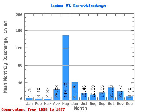
| Statistic | Jan | Feb | Mar | Apr | May | Jun | Jul | Aug | Sep | Oct | Nov | Dec | Annual |
|---|---|---|---|---|---|---|---|---|---|---|---|---|---|
| Mean | 4.76 | 3.13 | 2.82 | 25.08 | 149.68 | 41.15 | 15.45 | 12.59 | 17.35 | 29.32 | 20.78 | 8.40 | 329.59 |
| Standard Deviation | 2.67 | 1.82 | 0.88 | 33.80 | 60.71 | 25.39 | 11.81 | 16.33 | 14.89 | 20.82 | 16.03 | 5.01 | 88.01 |
| Min | 1.84 | 1.31 | 1.53 | 1.98 | 40.94 | 12.40 | 3.69 | 2.49 | 2.09 | 3.16 | 3.35 | 1.95 | 169.00 |
| Max | 13.52 | 9.72 | 5.53 | 128.86 | 307.97 | 109.61 | 49.54 | 77.66 | 69.24 | 86.27 | 59.25 | 20.47 | 552.39 |
| Coefficient of Variation | 0.56 | 0.58 | 0.31 | 1.35 | 0.41 | 0.62 | 0.76 | 1.30 | 0.86 | 0.71 | 0.77 | 0.60 | 0.27 |
 Return to R-Arctic Net Home Page