|
|
|||||||||||||||||
| Point ID: 7455 | Downloads | Plots | Site Data | Code: 70356 |
|
|
|||||||||||||||||
| Download | |
|---|---|
| Site Descriptor Information | Site Time Series Data |
| Link to all available data | |
| View: | Time Series | All |
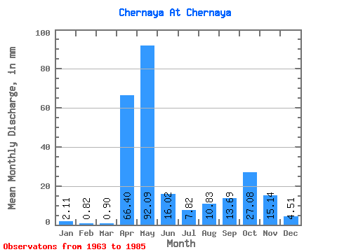
| Units: | m3/s |
| Statistic | Jan | Feb | Mar | Apr | May | Jun | Jul | Aug | Sep | Oct | Nov | Dec | Annual |
|---|---|---|---|---|---|---|---|---|---|---|---|---|---|
| Mean | 2.12 | 0.72 | 0.87 | 66.37 | 92.03 | 16.16 | 7.72 | 10.68 | 13.75 | 27.10 | 15.18 | 4.39 | 296.75 |
| Standard Deviation | 1.69 | 0.59 | 0.36 | 43.64 | 51.74 | 12.87 | 10.69 | 18.40 | 16.23 | 22.51 | 11.71 | 2.70 | 93.89 |
| Min | 0.30 | 0.27 | 0.30 | 0.29 | 25.88 | 2.62 | 0.30 | 0.30 | 0.29 | 0.30 | 0.87 | 0.30 | 156.03 |
| Max | 5.72 | 1.92 | 1.50 | 161.05 | 180.54 | 49.51 | 33.10 | 57.17 | 64.07 | 78.84 | 40.77 | 9.33 | 389.48 |
| Coefficient of Variation | 0.80 | 0.82 | 0.41 | 0.66 | 0.56 | 0.80 | 1.39 | 1.72 | 1.18 | 0.83 | 0.77 | 0.62 | 0.32 |
 Return to R-Arctic Net Home Page