|
|
|||||||||||||||||
| Point ID: 7441 | Downloads | Plots | Site Data | Code: 70329 |
|
|
|||||||||||||||||
| Download | |
|---|---|
| Site Descriptor Information | Site Time Series Data |
| Link to all available data | |
| View: | Time Series | All |
| Units: | m3/s |
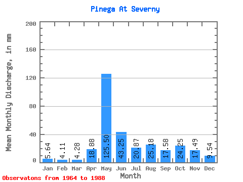
| Statistic | Jan | Feb | Mar | Apr | May | Jun | Jul | Aug | Sep | Oct | Nov | Dec | Annual |
|---|---|---|---|---|---|---|---|---|---|---|---|---|---|
| Mean | 5.64 | 4.15 | 4.28 | 18.88 | 125.48 | 43.25 | 20.87 | 25.18 | 17.58 | 24.25 | 17.48 | 9.54 | 312.59 |
| Standard Deviation | 1.59 | 1.08 | 0.99 | 24.45 | 33.95 | 17.08 | 12.38 | 52.71 | 8.85 | 11.09 | 8.61 | 4.40 | 69.30 |
| Min | 2.50 | 2.04 | 2.60 | 4.01 | 60.91 | 18.17 | 6.07 | 6.14 | 5.44 | 8.32 | 6.23 | 5.01 | 204.61 |
| Max | 9.69 | 6.08 | 7.43 | 110.54 | 190.61 | 83.86 | 54.61 | 265.18 | 36.09 | 52.77 | 35.32 | 21.87 | 584.17 |
| Coefficient of Variation | 0.28 | 0.26 | 0.23 | 1.29 | 0.27 | 0.40 | 0.59 | 2.09 | 0.50 | 0.46 | 0.49 | 0.46 | 0.22 |
 Return to R-Arctic Net Home Page