|
|
|||||||||||||||||
| Point ID: 7436 | Downloads | Plots | Site Data | Code: 70309 |
|
|
|||||||||||||||||
| Download | |
|---|---|
| Site Descriptor Information | Site Time Series Data |
| Link to all available data | |
| View: | Time Series | All |
| Units: | m3/s |
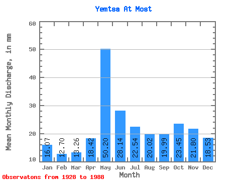
| Statistic | Jan | Feb | Mar | Apr | May | Jun | Jul | Aug | Sep | Oct | Nov | Dec | Annual |
|---|---|---|---|---|---|---|---|---|---|---|---|---|---|
| Mean | 16.07 | 12.81 | 13.26 | 18.42 | 50.19 | 28.14 | 22.54 | 20.02 | 19.99 | 23.44 | 21.80 | 18.53 | 266.24 |
| Standard Deviation | 3.51 | 2.63 | 2.56 | 8.41 | 16.99 | 9.68 | 6.10 | 5.16 | 6.71 | 8.67 | 7.20 | 4.19 | 57.25 |
| Min | 10.54 | 7.07 | 7.66 | 8.40 | 19.44 | 14.35 | 12.34 | 9.66 | 9.04 | 10.38 | 10.13 | 10.02 | 152.14 |
| Max | 26.06 | 20.46 | 21.02 | 44.31 | 84.80 | 64.80 | 41.32 | 36.43 | 41.81 | 49.67 | 45.57 | 27.93 | 384.31 |
| Coefficient of Variation | 0.22 | 0.21 | 0.19 | 0.46 | 0.34 | 0.34 | 0.27 | 0.26 | 0.34 | 0.37 | 0.33 | 0.23 | 0.21 |
 Return to R-Arctic Net Home Page