|
|
|||||||||||||||||
| Point ID: 7422 | Downloads | Plots | Site Data | Code: 70281 |
|
|
|||||||||||||||||
| Download | |
|---|---|
| Site Descriptor Information | Site Time Series Data |
| Link to all available data | |
| View: | Time Series | All |
| Units: | m3/s |
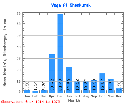
| Statistic | Jan | Feb | Mar | Apr | May | Jun | Jul | Aug | Sep | Oct | Nov | Dec | Annual |
|---|---|---|---|---|---|---|---|---|---|---|---|---|---|
| Mean | 2.56 | 1.96 | 2.30 | 33.42 | 68.48 | 22.50 | 10.22 | 10.32 | 10.90 | 16.87 | 11.91 | 3.98 | 194.37 |
| Standard Deviation | 1.23 | 0.71 | 0.77 | 21.19 | 25.91 | 10.94 | 4.88 | 11.68 | 9.12 | 12.68 | 10.24 | 2.48 | 54.53 |
| Min | 0.98 | 1.05 | 1.42 | 2.27 | 13.39 | 4.98 | 4.28 | 3.51 | 3.40 | 0.76 | 0.61 | 0.57 | 119.34 |
| Max | 5.57 | 4.54 | 5.22 | 84.38 | 111.58 | 52.92 | 22.53 | 54.88 | 37.60 | 63.05 | 43.54 | 11.51 | 324.85 |
| Coefficient of Variation | 0.48 | 0.36 | 0.33 | 0.63 | 0.38 | 0.49 | 0.48 | 1.13 | 0.84 | 0.75 | 0.86 | 0.62 | 0.28 |
 Return to R-Arctic Net Home Page