|
|
|||||||||||||||||
| Point ID: 7421 | Downloads | Plots | Site Data | Code: 70275 |
|
|
|||||||||||||||||
| Download | |
|---|---|
| Site Descriptor Information | Site Time Series Data |
| Link to all available data | |
| View: | Time Series | All |
| Units: | m3/s |
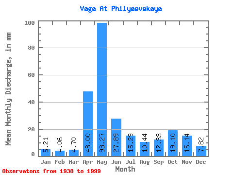
| Statistic | Jan | Feb | Mar | Apr | May | Jun | Jul | Aug | Sep | Oct | Nov | Dec | Annual |
|---|---|---|---|---|---|---|---|---|---|---|---|---|---|
| Mean | 5.21 | 4.10 | 4.70 | 48.00 | 98.26 | 27.89 | 15.29 | 10.44 | 12.33 | 19.10 | 15.14 | 7.81 | 267.35 |
| Standard Deviation | 1.82 | 1.18 | 1.60 | 32.45 | 42.22 | 17.26 | 10.55 | 8.91 | 10.27 | 13.04 | 10.16 | 3.72 | 59.72 |
| Min | 2.19 | 1.78 | 2.90 | 4.20 | 27.19 | 6.40 | 3.73 | 3.77 | 3.93 | 5.01 | 3.67 | 3.00 | 146.90 |
| Max | 11.06 | 7.15 | 13.73 | 131.56 | 208.97 | 93.67 | 53.76 | 52.34 | 45.95 | 54.98 | 52.43 | 22.72 | 435.38 |
| Coefficient of Variation | 0.35 | 0.29 | 0.34 | 0.68 | 0.43 | 0.62 | 0.69 | 0.85 | 0.83 | 0.68 | 0.67 | 0.48 | 0.22 |
 Return to R-Arctic Net Home Page