|
|
|||||||||||||||||
| Point ID: 741 | Downloads | Plots | Site Data | Code: 07FD921 |
|
|
|||||||||||||||||
| Download | |
|---|---|
| Site Descriptor Information | Site Time Series Data |
| Link to all available data | |
| View: | Time Series | All |
| Units: | m3/s |
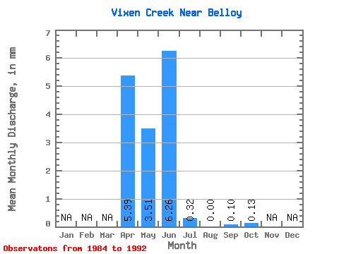
| Statistic | Jan | Feb | Mar | Apr | May | Jun | Jul | Aug | Sep | Oct | Nov | Dec | Annual |
|---|---|---|---|---|---|---|---|---|---|---|---|---|---|
| Mean | 5.40 | 3.51 | 6.25 | 0.32 | 0.00 | 0.11 | 0.14 | ||||||
| Standard Deviation | 4.63 | 7.00 | 18.11 | 0.81 | 0.00 | 0.33 | 0.40 | ||||||
| Min | 0.14 | 0.00 | 0.00 | 0.00 | 0.00 | 0.00 | 0.00 | ||||||
| Max | 11.45 | 21.42 | 54.54 | 2.44 | 0.00 | 0.97 | 1.20 | ||||||
| Coefficient of Variation | 0.86 | 1.99 | 2.90 | 2.49 | 3.00 | 2.88 |
 Return to R-Arctic Net Home Page