|
|
|||||||||||||||||
| Point ID: 7405 | Downloads | Plots | Site Data | Code: 70232 |
|
|
|||||||||||||||||
| Download | |
|---|---|
| Site Descriptor Information | Site Time Series Data |
| Link to all available data | |
| View: | Time Series | All |
| Units: | m3/s |
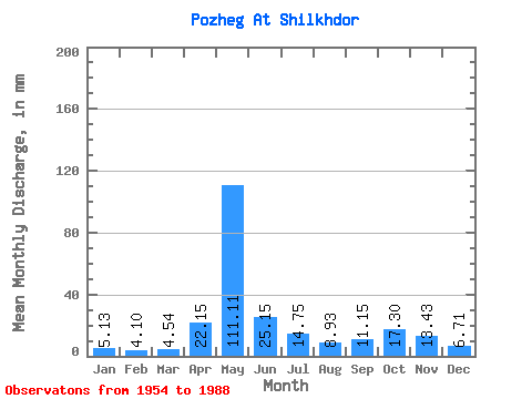
| Statistic | Jan | Feb | Mar | Apr | May | Jun | Jul | Aug | Sep | Oct | Nov | Dec | Annual |
|---|---|---|---|---|---|---|---|---|---|---|---|---|---|
| Mean | 5.13 | 4.13 | 4.54 | 22.15 | 111.09 | 25.15 | 14.75 | 8.93 | 11.15 | 17.30 | 13.43 | 6.71 | 241.21 |
| Standard Deviation | 1.39 | 1.08 | 0.92 | 19.36 | 41.59 | 11.26 | 9.93 | 5.70 | 7.21 | 8.64 | 7.49 | 2.46 | 46.85 |
| Min | 2.02 | 1.97 | 3.12 | 4.61 | 22.02 | 7.24 | 4.14 | 3.69 | 4.19 | 4.73 | 2.98 | 2.72 | 99.03 |
| Max | 9.34 | 7.64 | 7.75 | 86.83 | 181.51 | 54.00 | 47.31 | 27.82 | 35.14 | 33.48 | 35.57 | 15.62 | 311.83 |
| Coefficient of Variation | 0.27 | 0.26 | 0.20 | 0.87 | 0.37 | 0.45 | 0.67 | 0.64 | 0.65 | 0.50 | 0.56 | 0.37 | 0.19 |
 Return to R-Arctic Net Home Page