|
|
|||||||||||||||||
| Point ID: 7400 | Downloads | Plots | Site Data | Code: 70221 |
|
|
|||||||||||||||||
| Download | |
|---|---|
| Site Descriptor Information | Site Time Series Data |
| Link to all available data | |
| View: | Time Series | All |
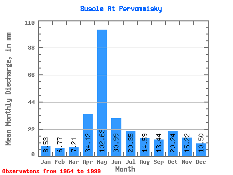
| Units: | m3/s |
| Statistic | Jan | Feb | Mar | Apr | May | Jun | Jul | Aug | Sep | Oct | Nov | Dec | Annual |
|---|---|---|---|---|---|---|---|---|---|---|---|---|---|
| Mean | 8.52 | 6.83 | 7.21 | 34.12 | 102.61 | 30.99 | 20.34 | 14.58 | 13.44 | 20.24 | 15.22 | 10.50 | 283.34 |
| Standard Deviation | 2.01 | 1.48 | 1.39 | 26.11 | 41.34 | 15.35 | 10.30 | 8.01 | 5.01 | 7.95 | 6.40 | 2.95 | 58.88 |
| Min | 3.30 | 2.65 | 2.93 | 8.33 | 24.49 | 10.59 | 5.17 | 3.32 | 3.92 | 9.13 | 5.12 | 3.00 | 123.32 |
| Max | 14.28 | 11.30 | 9.98 | 103.02 | 197.76 | 63.80 | 49.90 | 45.78 | 27.03 | 38.00 | 38.10 | 17.95 | 395.40 |
| Coefficient of Variation | 0.23 | 0.22 | 0.19 | 0.77 | 0.40 | 0.49 | 0.51 | 0.55 | 0.37 | 0.39 | 0.42 | 0.28 | 0.21 |
 Return to R-Arctic Net Home Page