|
|
|||||||||||||||||
| Point ID: 740 | Downloads | Plots | Site Data | Code: 07FD913 |
|
|
|||||||||||||||||
| Download | |
|---|---|
| Site Descriptor Information | Site Time Series Data |
| Link to all available data | |
| View: | Time Series | All |
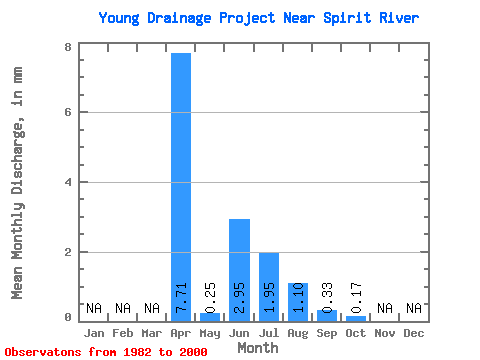
| Units: | m3/s |
| Statistic | Jan | Feb | Mar | Apr | May | Jun | Jul | Aug | Sep | Oct | Nov | Dec | Annual |
|---|---|---|---|---|---|---|---|---|---|---|---|---|---|
| Mean | 7.67 | 0.22 | 2.99 | 1.94 | 1.08 | 0.30 | 0.19 | ||||||
| Standard Deviation | 11.22 | 0.41 | 9.31 | 4.92 | 3.89 | 1.06 | 0.76 | ||||||
| Min | 0.00 | 0.00 | 0.00 | 0.00 | 0.00 | 0.00 | 0.00 | ||||||
| Max | 34.86 | 1.61 | 40.44 | 21.19 | 16.95 | 4.59 | 3.14 | ||||||
| Coefficient of Variation | 1.46 | 1.82 | 3.11 | 2.53 | 3.59 | 3.56 | 4.01 |
 Return to R-Arctic Net Home Page