|
|
|||||||||||||||||
| Point ID: 739 | Downloads | Plots | Site Data | Code: 07FD912 |
|
|
|||||||||||||||||
| Download | |
|---|---|
| Site Descriptor Information | Site Time Series Data |
| Link to all available data | |
| View: | Time Series | All |
| Units: | m3/s |
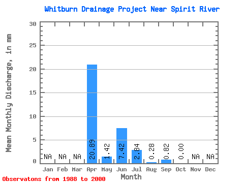
| Statistic | Jan | Feb | Mar | Apr | May | Jun | Jul | Aug | Sep | Oct | Nov | Dec | Annual |
|---|---|---|---|---|---|---|---|---|---|---|---|---|---|
| Mean | 21.03 | 1.40 | 7.36 | 2.80 | 0.41 | 0.87 | 0.05 | ||||||
| Standard Deviation | 25.72 | 3.15 | 19.49 | 5.56 | 1.14 | 2.81 | 0.17 | ||||||
| Min | 0.82 | 0.00 | 0.00 | 0.00 | 0.00 | 0.00 | 0.00 | ||||||
| Max | 83.01 | 11.36 | 71.74 | 19.59 | 3.98 | 10.17 | 0.57 | ||||||
| Coefficient of Variation | 1.22 | 2.25 | 2.65 | 1.99 | 2.75 | 3.24 | 3.32 |
 Return to R-Arctic Net Home Page