|
|
|||||||||||||||||
| Point ID: 7361 | Downloads | Plots | Site Data | Code: 70130 |
|
|
|||||||||||||||||
| Download | |
|---|---|
| Site Descriptor Information | Site Time Series Data |
| Link to all available data | |
| View: | Time Series | All |
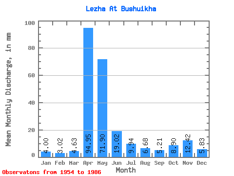
| Units: | m3/s |
| Statistic | Jan | Feb | Mar | Apr | May | Jun | Jul | Aug | Sep | Oct | Nov | Dec | Annual |
|---|---|---|---|---|---|---|---|---|---|---|---|---|---|
| Mean | 4.00 | 3.05 | 4.63 | 94.95 | 71.89 | 19.02 | 9.94 | 6.68 | 5.20 | 8.90 | 12.42 | 5.83 | 249.58 |
| Standard Deviation | 1.48 | 0.93 | 3.94 | 43.77 | 53.31 | 20.87 | 9.62 | 4.54 | 3.97 | 11.17 | 13.30 | 3.22 | 78.03 |
| Min | 2.20 | 0.97 | 1.24 | 37.09 | 5.05 | 2.15 | 2.18 | 2.44 | 2.36 | 2.68 | 2.51 | 2.61 | 120.04 |
| Max | 8.49 | 5.14 | 20.25 | 219.16 | 230.79 | 75.23 | 42.02 | 20.90 | 18.16 | 61.18 | 56.48 | 12.56 | 410.75 |
| Coefficient of Variation | 0.37 | 0.31 | 0.85 | 0.46 | 0.74 | 1.10 | 0.97 | 0.68 | 0.76 | 1.25 | 1.07 | 0.55 | 0.31 |
 Return to R-Arctic Net Home Page