|
|
|||||||||||||||||
| Point ID: 7359 | Downloads | Plots | Site Data | Code: 70128 |
|
|
|||||||||||||||||
| Download | |
|---|---|
| Site Descriptor Information | Site Time Series Data |
| Link to all available data | |
| View: | Time Series | All |
| Units: | m3/s |
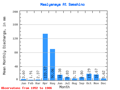
| Statistic | Jan | Feb | Mar | Apr | May | Jun | Jul | Aug | Sep | Oct | Nov | Dec | Annual |
|---|---|---|---|---|---|---|---|---|---|---|---|---|---|
| Mean | 3.60 | 1.92 | 2.38 | 133.57 | 90.05 | 16.38 | 8.83 | 5.71 | 8.80 | 19.29 | 16.67 | 5.62 | 313.12 |
| Standard Deviation | 4.05 | 1.61 | 2.25 | 65.22 | 79.42 | 28.37 | 11.84 | 11.11 | 15.42 | 25.94 | 18.64 | 5.71 | 100.14 |
| Min | 0.65 | 0.24 | 0.23 | 20.02 | 3.59 | 1.16 | 0.66 | 0.35 | 0.31 | 0.36 | 0.78 | 0.68 | 135.13 |
| Max | 18.94 | 6.05 | 10.67 | 290.81 | 272.15 | 132.76 | 48.34 | 54.54 | 64.38 | 100.37 | 83.24 | 21.55 | 525.25 |
| Coefficient of Variation | 1.12 | 0.83 | 0.95 | 0.49 | 0.88 | 1.73 | 1.34 | 1.94 | 1.75 | 1.34 | 1.12 | 1.02 | 0.32 |
 Return to R-Arctic Net Home Page