|
|
|||||||||||||||||
| Point ID: 7353 | Downloads | Plots | Site Data | Code: 70109 |
|
|
|||||||||||||||||
| Download | |
|---|---|
| Site Descriptor Information | Site Time Series Data |
| Link to all available data | |
| View: | Time Series | All |
| Units: | m3/s |
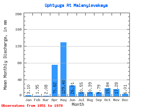
| Statistic | Jan | Feb | Mar | Apr | May | Jun | Jul | Aug | Sep | Oct | Nov | Dec | Annual |
|---|---|---|---|---|---|---|---|---|---|---|---|---|---|
| Mean | 3.10 | 1.96 | 2.07 | 75.82 | 129.39 | 26.01 | 10.55 | 10.39 | 9.79 | 19.83 | 17.28 | 6.01 | 312.96 |
| Standard Deviation | 1.89 | 1.21 | 1.31 | 53.24 | 78.18 | 21.04 | 12.19 | 20.48 | 14.74 | 18.18 | 15.32 | 5.86 | 107.18 |
| Min | 0.82 | 0.51 | 0.56 | 4.70 | 12.57 | 4.28 | 0.95 | 0.82 | 1.47 | 1.65 | 1.34 | 1.17 | 156.22 |
| Max | 7.45 | 5.05 | 6.54 | 201.74 | 317.63 | 73.82 | 58.93 | 101.40 | 59.98 | 67.17 | 64.17 | 28.12 | 539.19 |
| Coefficient of Variation | 0.61 | 0.61 | 0.63 | 0.70 | 0.60 | 0.81 | 1.16 | 1.97 | 1.50 | 0.92 | 0.89 | 0.98 | 0.34 |
 Return to R-Arctic Net Home Page