|
|
|||||||||||||||||
| Point ID: 7352 | Downloads | Plots | Site Data | Code: 70102 |
|
|
|||||||||||||||||
| Download | |
|---|---|
| Site Descriptor Information | Site Time Series Data |
| Link to all available data | |
| View: | Time Series | All |
| Units: | m3/s |
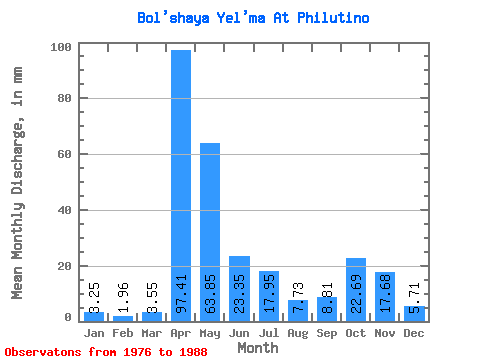
| Statistic | Jan | Feb | Mar | Apr | May | Jun | Jul | Aug | Sep | Oct | Nov | Dec | Annual |
|---|---|---|---|---|---|---|---|---|---|---|---|---|---|
| Mean | 3.26 | 1.98 | 3.55 | 97.40 | 63.85 | 23.35 | 17.95 | 7.73 | 8.82 | 22.69 | 17.68 | 5.71 | 274.03 |
| Standard Deviation | 3.79 | 2.06 | 4.36 | 37.52 | 41.04 | 31.17 | 15.63 | 9.94 | 10.92 | 23.49 | 13.27 | 4.10 | 49.00 |
| Min | 0.53 | 0.29 | 0.46 | 45.77 | 10.13 | 1.58 | 0.68 | 0.52 | 0.82 | 1.20 | 0.81 | 0.85 | 183.92 |
| Max | 13.99 | 7.59 | 17.42 | 149.54 | 142.48 | 93.88 | 57.25 | 30.04 | 29.99 | 75.62 | 37.38 | 13.13 | 340.26 |
| Coefficient of Variation | 1.17 | 1.04 | 1.23 | 0.39 | 0.64 | 1.33 | 0.87 | 1.29 | 1.24 | 1.03 | 0.75 | 0.72 | 0.18 |
 Return to R-Arctic Net Home Page