|
|
|||||||||||||||||
| Point ID: 7349 | Downloads | Plots | Site Data | Code: 70085 |
|
|
|||||||||||||||||
| Download | |
|---|---|
| Site Descriptor Information | Site Time Series Data |
| Link to all available data | |
| View: | Time Series | All |
| Units: | m3/s |
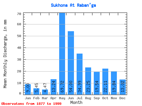
| Statistic | Jan | Feb | Mar | Apr | May | Jun | Jul | Aug | Sep | Oct | Nov | Dec | Annual |
|---|---|---|---|---|---|---|---|---|---|---|---|---|---|
| Mean | 9.00 | 5.50 | 4.47 | 13.24 | 69.71 | 54.00 | 34.98 | 23.24 | 19.54 | 22.11 | 19.84 | 13.02 | 291.36 |
| Standard Deviation | 5.20 | 3.28 | 2.48 | 12.48 | 24.84 | 21.79 | 15.49 | 11.38 | 11.19 | 12.17 | 12.17 | 7.62 | 78.35 |
| Min | 2.07 | 1.51 | 1.48 | 0.25 | 5.68 | 9.68 | 11.54 | 4.87 | 3.31 | 2.25 | 1.82 | 2.12 | 139.13 |
| Max | 25.40 | 17.32 | 12.66 | 62.04 | 127.16 | 112.71 | 84.66 | 68.94 | 60.03 | 59.26 | 54.85 | 39.39 | 514.77 |
| Coefficient of Variation | 0.58 | 0.60 | 0.56 | 0.94 | 0.36 | 0.40 | 0.44 | 0.49 | 0.57 | 0.55 | 0.61 | 0.58 | 0.27 |
 Return to R-Arctic Net Home Page